
| Sanborn Field - Columbia | ||
68°F | ||
| Humidity | 93% | |
| Wind Speed | 3.4 mph | |
| Wind Dir. | ENE | |
| Pressure |  | |
| 74.5°F | ||
| Rainfall | 0.58 in. | |
May 2024 Weather and Its Impacts on Missouri
Dr. Pat Guinan |
Dr. Zachary Leasor |
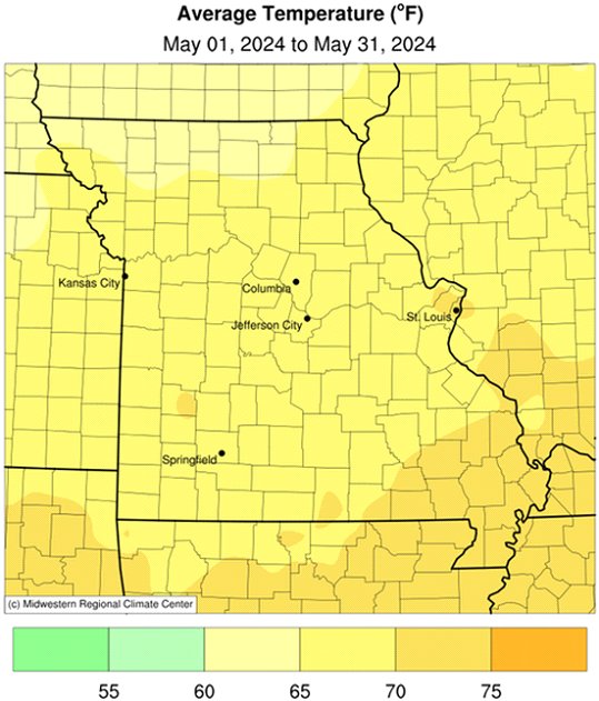
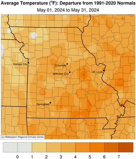
Except for a few days, daily maximum and minimum temperatures in Missouri were above average during the entire month of May, Figure 1. Preliminary data for the state indicates an average statewide temperature of 67.9°F, or 3.7°F above the long-term average, Figure 2. Over the past 17 months, only one month has been cooler than normal, Figure 3.
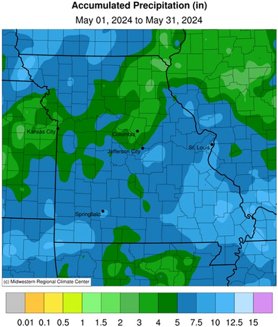
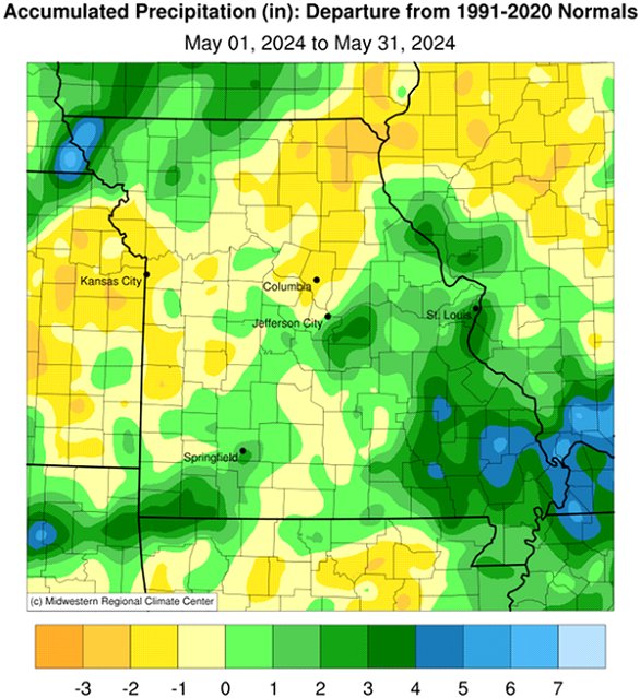
May precipitation was variable with preliminary data indicating a statewide average total of 5.81 inches, 1.15 inches above the long-term average. It was the wettest May in two years and followed the trend, where 21 out of past 30 Mays (70%) have been above average, Figure 4. Three out of the past five months have been wetter than average, Figure 5.
Heaviest May rainfall occurred in northwestern, eastern, and southern parts of the state where 5-8 inches were common. There were reports of 10-11 inches in several far southeastern counties as well as localized areas in far southwestern and extreme northwestern Missouri. Below average totals were found across northeastern, north central, central, and west central Missouri, and ranged from 3-5 inches.
Preliminary data for the spring season (Mar-Apr-May) indicates an average temperature of 58.8°F, or 4.7° above the long-term average, Figure 6. It was the third warmest spring for Missouri in the past 130 years, and the warmest since 2012. Over the past 25 years, there have been only five cooler than average springs.
Preliminary precipitation data for the spring season indicates a statewide average total of 14.27 inches or 2.43 inches above the long-term average, Figure 7. There have been only two drier than average springs in Missouri over the past decade.
Drought conditions improved notably during May. According to the U.S. Drought Monitor for May 28, 2024, there was no drought impacting Missouri, Figure 8. Abnormally dry (D0) conditions were affecting a few far southeastern counties. This was the first time in nearly two years when an official drought category (D1-D-4) was not impacting an area of the state.
According to the Missouri Agricultural Statistics Service, as of May 26, 2024, corn planting was 87% planted, close to the 5-year average of 86%, 93% of the corn had emerged; 60% of the corn was in good condition and 27% fair. Soybean was 55% planted, compared to the 5-year average of 46%. Pasture conditions were reported 5% excellent, 67% good, 25% fair, and 3% poor. Hay supplies and other roughages were listed at 2% surplus, 76% adequate, 19% short and 3% very short. Stock water supplies were 8% surplus, 86% adequate and 6% short. Topsoil moisture supplies were 26% surplus, 72% adequate and 2% short, while subsoil moisture supplies were 16% surplus, 79% adequate, and 5% short.
A spectacular display of Northern Lights occurred over parts of the globe, including much of the United States (and all of Missouri), during the evening of May 10, 2024, Figures 9-15. A geomagnetic storm, the strongest in more than 20 years, resulted in widespread and vivid displays of the Aurora Borealis. There were many reports of the sky covered in beautiful shades of red, green, blue, pink, and purple, appearing like shimmering and pulsing curtains of colorful light.
Jump to:
- Figure 1
- Figure 2
- Figure 3
- Figure 4
- Figure 5
- Figure 6
- Figure 7
- Figure 8
- Figure 9
- Figure 10
- Figure 11
- Figure 12
- Figure 13
- Figure 14
- Figure 15
- Figure 16
- Figure 17
- Figure 18
- Figure 19
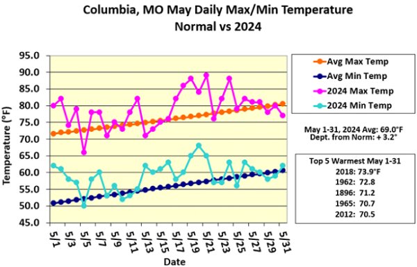
Figure 1.
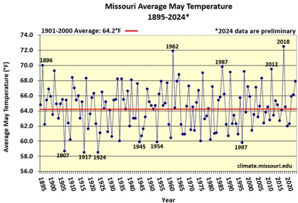
Figure 2.
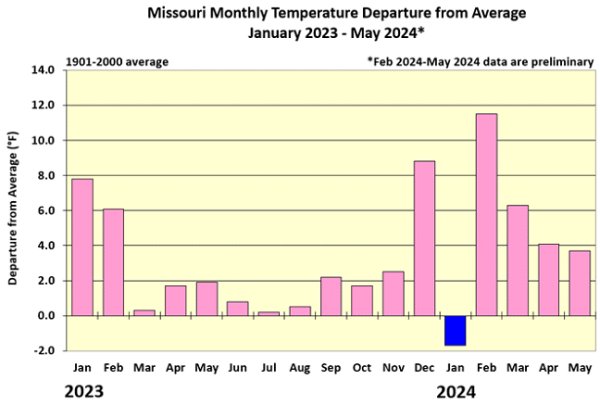
Figure 3.
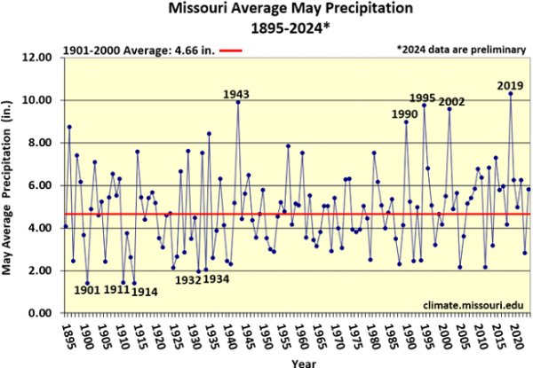
Figure 4.
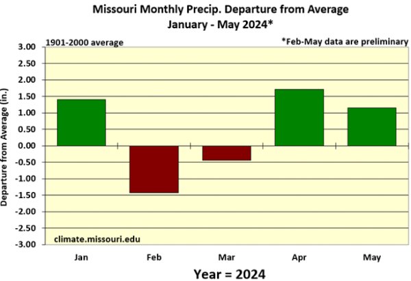
Figure 5.
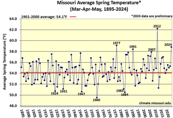
Figure 6.
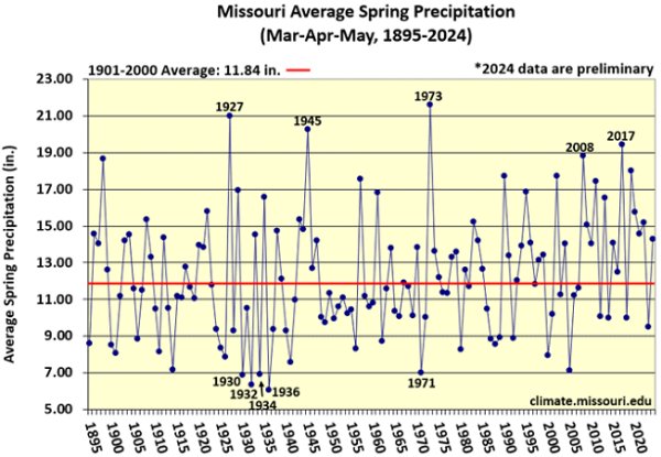
Figure 7.
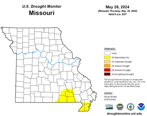
Figure 8.
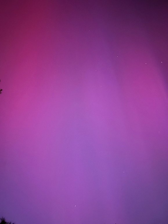
Figure 9. Aurora Borealis, May 10, 2024, 9:00-10:00 p.m. CDT, Columbia, Missouri.
Photo Credit: Pat Guinan, iPhone 14
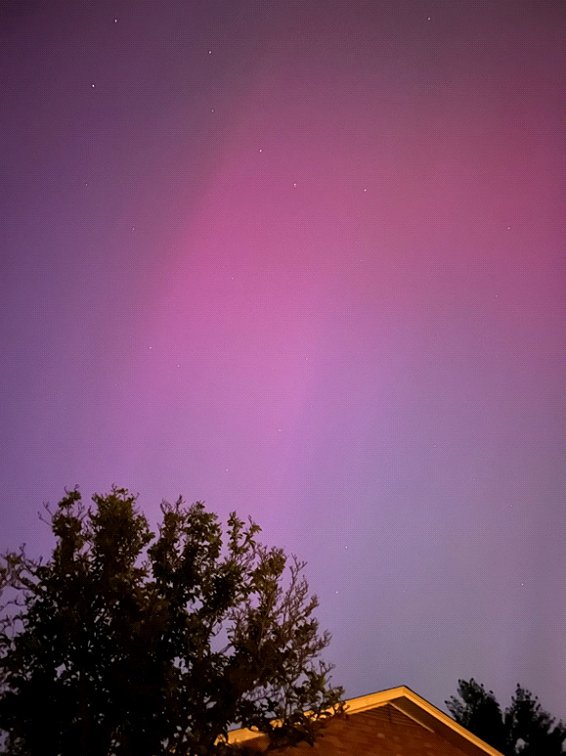
Figure 10. Aurora Borealis, May 10, 2024, 9:00-10:00 p.m. CDT, Columbia, Missouri.
Photo Credit: Pat Guinan, iPhone 14
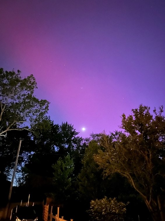
Figure 11. Aurora Borealis, May 10, 2024, 9:00-10:00 p.m. CDT, Columbia, Missouri.
Photo Credit: Pat Guinan, iPhone 14
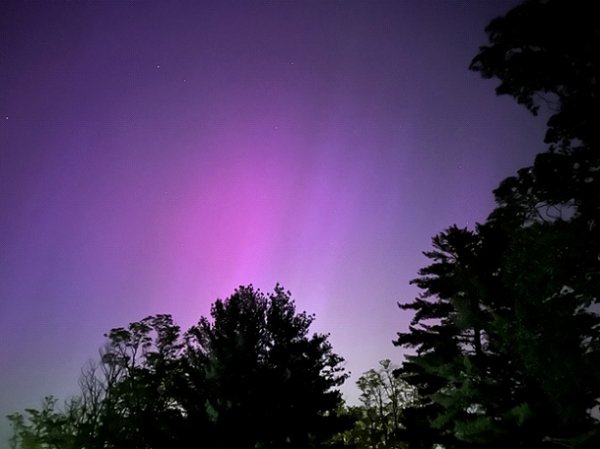
Figure 12. Aurora Borealis, May 10, 2024, 9:00-10:00 p.m. CDT, Columbia, Missouri.
Photo Credit: Pat Guinan, iPhone 14
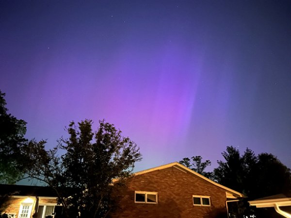
Figure 13. Aurora Borealis, May 10, 2024, 9:00-10:00 p.m. CDT, Columbia, Missouri.
Photo Credit: Pat Guinan, iPhone 14
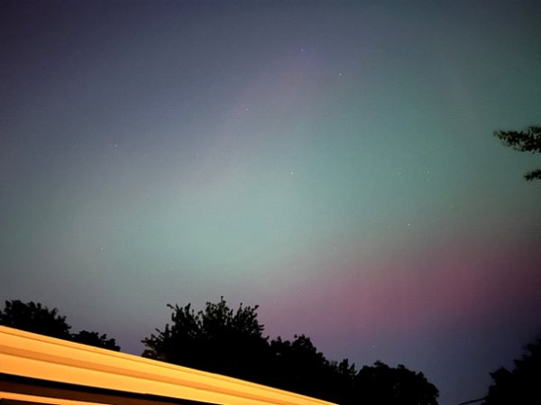
Figure 14. Aurora Borealis, May 10, 2024, 9:00-10:00 p.m. CDT, Columbia, Missouri.
Photo Credit: Pat Guinan, iPhone 14
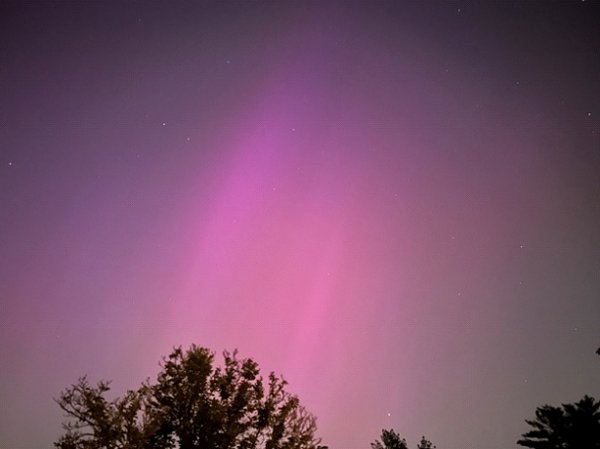
Figure 15. Aurora Borealis, May 10, 2024, 9:00-10:00 p.m. CDT, Columbia, Missouri.
Photo Credit: Pat Guinan, iPhone 14
Source: Dr. Pat Guinan and Dr. Zack Leasor | 573-882-5908